Skip to content
Home » airport » airportlandscapes » large commercial

large commercial

Home » airport » airportlandscapes » large commercial

Swipe map to reveal full extent (east-west). Zoom-in (click/pinch) for more detail.

London Heathrow Airport, located in the London Borough of Hillingdon, began its operations in 1946 as a civil aviation airport, initially using ex-military tents as terminal buildings. Originally known as London Airport, it was officially renamed Heathrow Airport in 1966, deriving its name from the small hamlet of Heathrow that previously existed on the site. The airport quickly established itself as a major hub for international travel, with its first transatlantic flight taking off in 1946.

The airport’s expansion has been significant over the decades. The first permanent terminal building, Terminal 1, opened in 1969, followed by the addition of Terminals 2, 3, 4, and 5 in subsequent years to accommodate the growing number of passengers. The development of Heathrow’s infrastructure included the construction of two runways and the creation of modern facilities designed to provide a seamless travel experience. The opening of the Heathrow Express rail link in 1998 further enhanced accessibility to central London, cementing the airport’s role as a crucial transportation hub.

LHR
From Heathrow United Airlines flies to Houston, TX twice a day, using aircraft such as this Boeing 777-200ER

Today, London Heathrow Airport is one of the busiest airports in the world, handling over 80 million passengers annually and serving as a primary gateway for international travel. The airport offers flights to over 180 destinations across more than 90 countries.

Fly to another aiport map: Southampton airport

© 2025 ZyXmaps.com

Historic Ordnance Survey mapping used for ZyXmaps’s ‘UK airport landscapes’ series is reproduced with the permission of the National Library of Scotland (CC-BY). Airport layout © Open Streetmap Contributors. Photographs © edition ND. 

Home » airport » airportlandscapes » large commercial

Swipe map to reveal full extent (east-west). Zoom-in (click/pinch) for more detail.

Edinburgh Airport, located in Ingliston, Edinburgh, began its life as Turnhouse Aerodrome in 1916, serving as a military airfield during World War I. The site was used primarily for the Royal Flying Corps, and later the Royal Air Force, playing a key role in Britain’s defense efforts. After World War II, the airfield transitioned to civilian use, and the first commercial flights took off from Edinburgh Airport in 1947.

A little stream, Gogar Burn, still flows through the central area of the airport. The shape of the airport in the south-eastern corner indicates the location of second runway 12/30 (NE-SWG, previously 13/31) which was decomissioned in 2018. 

Significant development occurred in the 1970s, with the opening of a new passenger terminal in 1977, designed to cater to the increasing number of travelers. The construction of a new runway was also completed in 1977, allowing the airport to accommodate larger aircraft and expand its route network. Over the years, Edinburgh Airport has continued to grow, with numerous upgrades and expansions to its facilities to keep up with the demand for air travel.

Ryanair at EDI
From Edinburgh Ryanair operates various domestic and international routes, to Bournemouth and for Gran Canaria, for example.

Today, Edinburgh Airport is Scotland’s busiest airport, handling over 14 million passengers annually and offering flights to more than 150 destinations worldwide.

Fly to another aiport map: London Heathrow airport

© 2025 ZyXmaps.com

Historic Ordnance Survey mapping used for ZyXmaps’s ‘UK airport landscapes’ series is reproduced with the permission of the National Library of Scotland (CC-BY). Airport layout © Open Streetmap Contributors. Photographs © edition ND. 

Home » airport » airportlandscapes » large commercial

Zoom-in on map (click/pinch) for more detail.

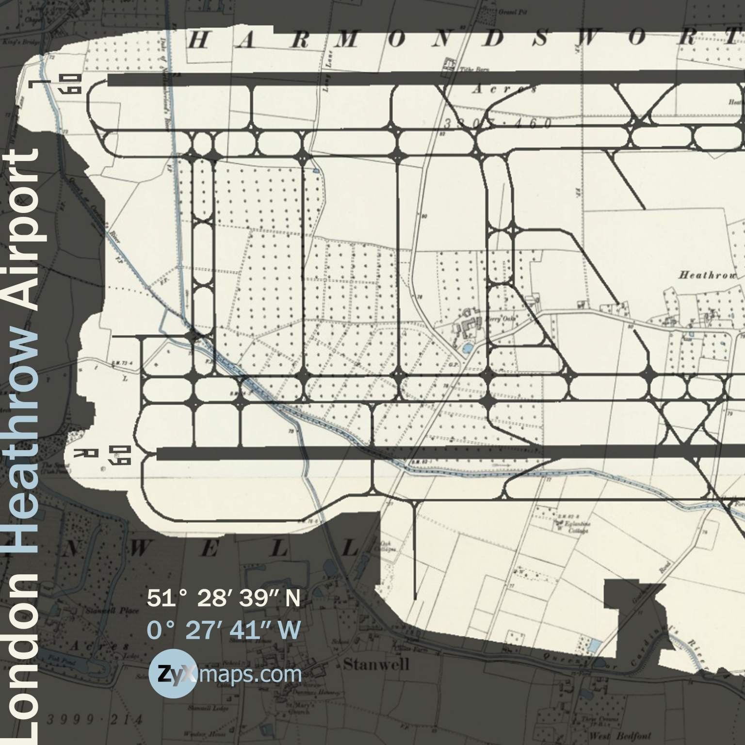
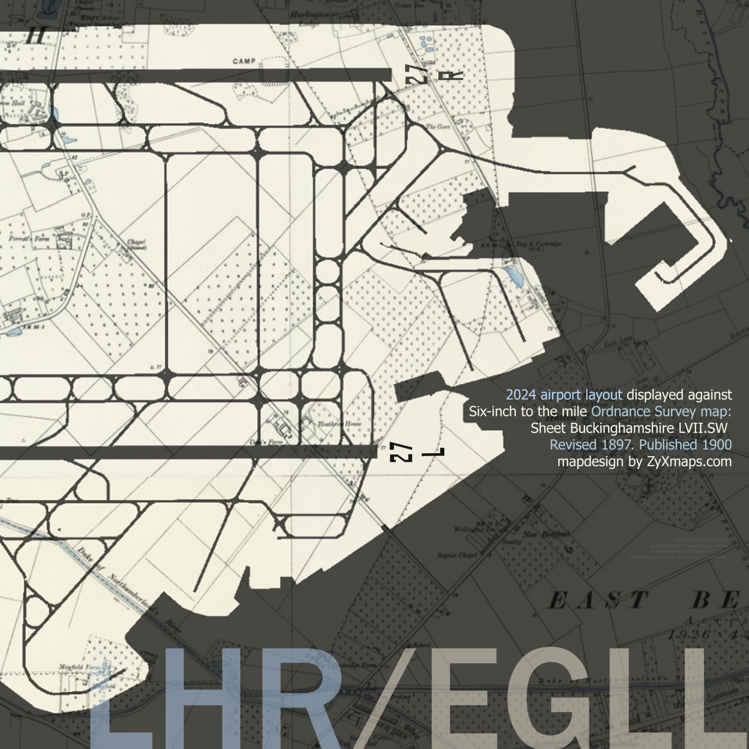
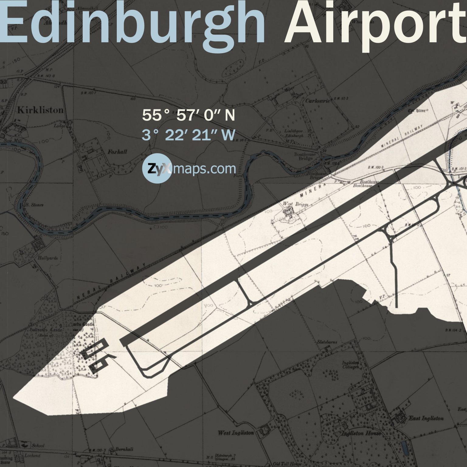
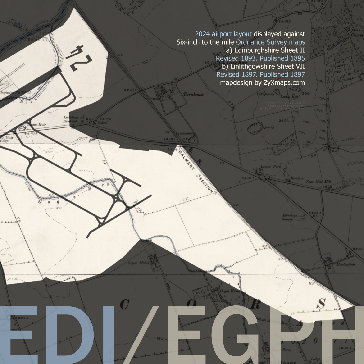
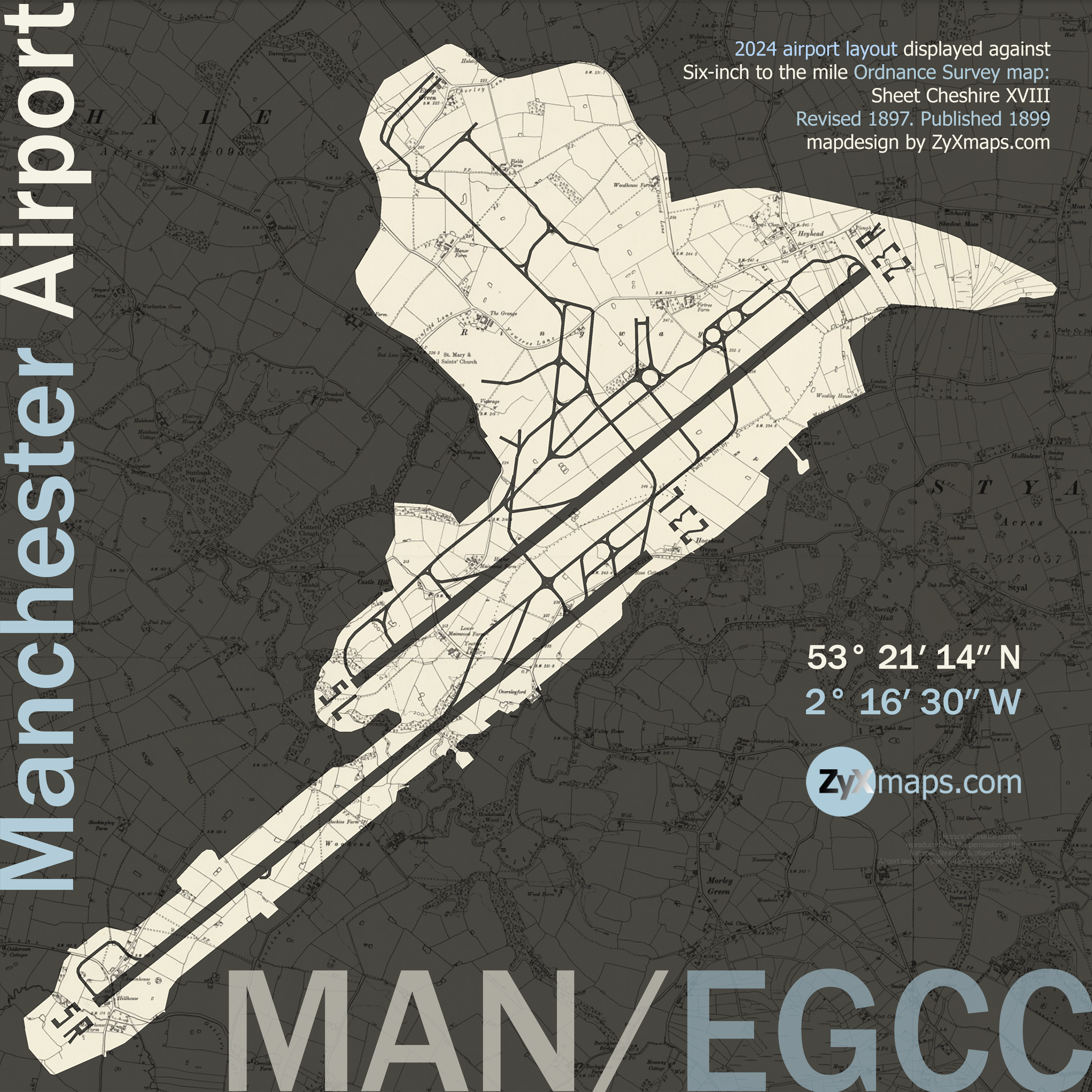
Manchester Airport, located in Ringway, Manchester, opened its doors in 1938. Originally known as Ringway Airport, it served as an important base for the Royal Air Force during World War II. Post-war, it transitioned to civil aviation and saw the introduction of transatlantic flights in the 1960s, positioning itself as a significant player in international air travel.

The airport underwent significant expansions in the latter half of the 20th century. The first major development was the opening of Terminal 1 in 1962, followed by Terminal 2 in 1993. These expansions facilitated increased passenger capacity and improved facilities, catering to the growing demand for air travel. Additionally, the airport’s rail station, which opened in 1993, enhanced connectivity, making it easier for travelers to access the airport from various locations. 

From Manchester KLM operates up to 5 flights a day to Amsterdam.

Today, Manchester Airport stands as the third busiest airport in the United Kingdom, serving over 29 million passengers annually. It boasts three passenger terminals and handles flights to over 200 destinations worldwide.

Fly to another aiport map: Edinburgh airport

© 2025 ZyXmaps.com

Historic Ordnance Survey mapping used for ZyXmaps’s ‘UK airport landscapes’ series is reproduced with the permission of the National Library of Scotland (CC-BY). Airport layout © Open Streetmap Contributors. Photographs © edition ND.